Tuesday, November 2, 2010
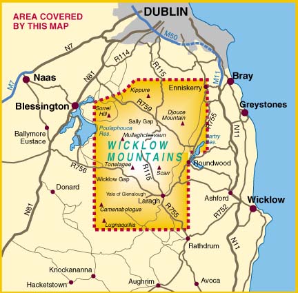
Wicklow Mountains National Park, Ireland
The Wicklow Mountains are located in the southeast of Ireland. The mountain rage runs in a north-south direction from the south Dublin across Wicklow and into Wexford. The mountains are made up of metamorphic rock and granite but after many tropical storms and ice sheets, much of the metamorphic rock eroded away and the granite that was once deeply buried became exposed. Then erosive forces of ice, wind and water shaped the new mountains over time into the rounded hills that can be seen today.

The Wicklow Mountains experience a marine west coast climate. Temperatures throughout the year range from 4°C to 23°C . There is abundant precipitation due to the orographic effect. The precipitation average is 6.21 cm. Summers in the mountains can vary dramatically with wide ranges in temperatures and conditions. Sometimes the weather can be dry and warm, or the weather can be cool and somewhat wet. Winters generally are wet and windy, with some cold clear days. Cold spells often occur during January and February. Unless it is a particularly cold winter, the temperatures rarely dip below zero during the day. Weather in the mountains often changes suddenly. It is possible to experience all four seasons on any given day throughout the year. The Irish are used to constant change and dress accordingly--no matter how clear it looks, always bring a jacket.
The Cloghoge Valley located in the Wicklow Mountains experienced a harsh rain storm in August 1986. This rain storm triggered four landslides, where rapid mass movement of soil transformed into high velocity that knocked down trees, stripped bark and piled mud and pebbles up to 5 m high on the side of trees. Active peat erosion is widespread in the Wicklow Mountains. There are two possible underlying causes of the erosion. One is that climatic change is either slowing peat accumulation or initiating erosion through storm damage. The second is that erosion could be from the influence of human disturbance through burning, trampling, drainage, deforestation or through industrial pollution.

The Wicklow Mountains have a great diversity of habitats which includes a blanket bog and heath and upland grassland being the most dominant. The Park also contains woodlands, glaciated corrie lakes and valleys, and exposed rock and scree. Botanists have identified and recorded more than 800 different plant species in the mountains. Some of the common trees that exist are Douglas Fir, and Silver Birch. The shrub layer includes Ivy, Honeysuckle and Bramble. The deciduous woodlands within the Park are of important conservation value due to the lack of native woodlands left in Ireland. The dominant tree within the main area of deciduous oakwood is the Sessile Oak. Wildflowers are also another common flora in the Wicklow Mountains, such as the Cuckoo flower and the Bluebell. There is also a large diversity of animals within the Park, including badgers, red deer and the Irish hare.
.jpg)
The primary purpose of Wicklow Mountains National Park is the conservation of local biodiversity and landscape. The Park is also an invaluable recreational space for locals and visitors alike where they can experience hiking, mountain biking, fishing, sailing and the wonderful outdoors.
¡Argentina!

Maps:
climate map en español, topographic map, and a
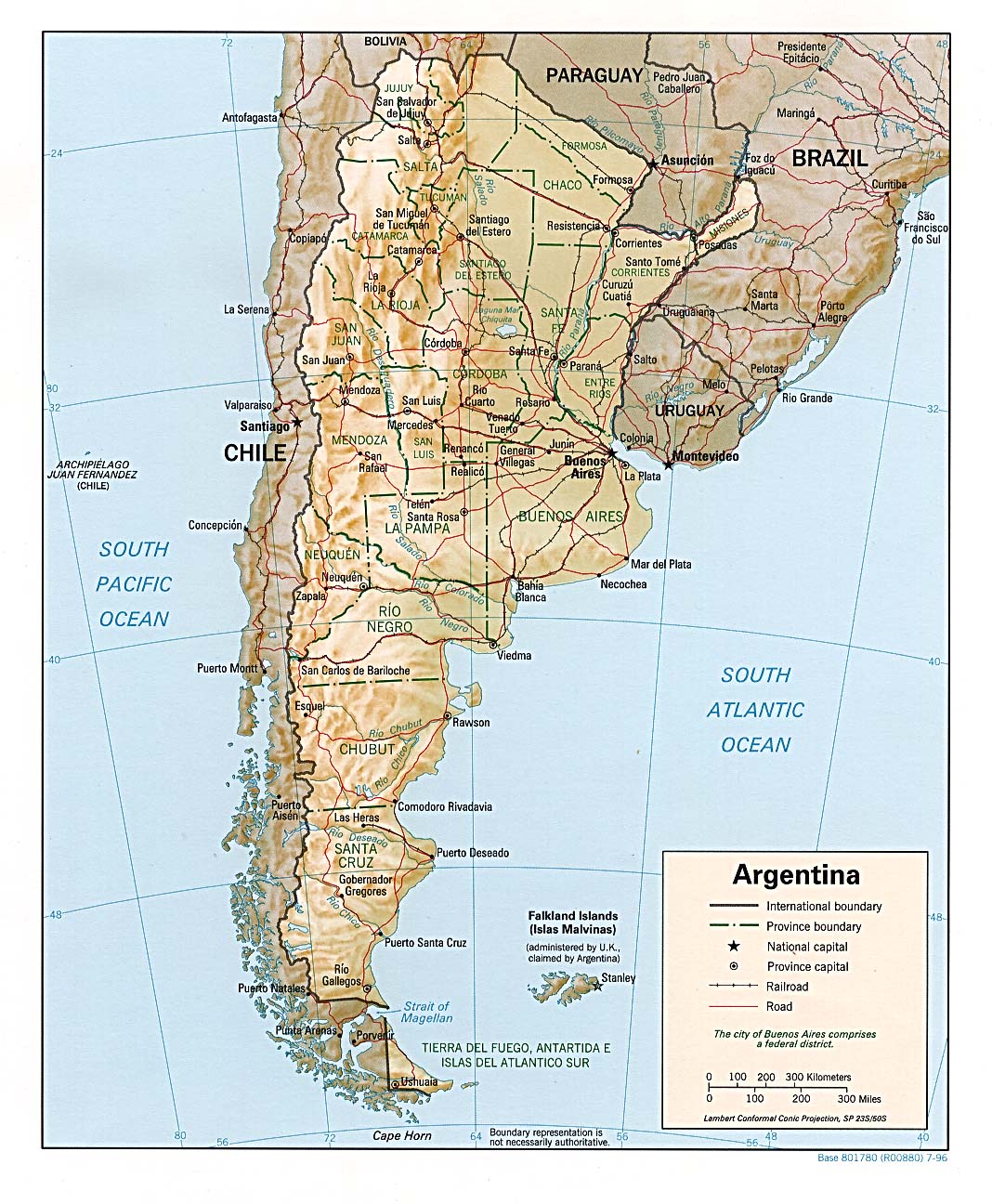
road map of Argenina including railroads and province boundaries.
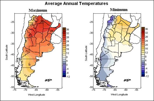
Argentina has a wide range of climates as it lies across multiple latitudes. The grasslands (the Pampas) in the northern half of the country are productive land for agriculture and grazing. Along the western side of Argentina is the Andes mountain range, which divides the country from Chile. Arid and semi-arid land makeup the southeast of Argentina. Patagonia is its most extensive climate, ranging from the southern most tip of Argentina near Antarctica to the central part of the country just east of the mountains. The annual temperatures of these regions are influenced by insolation according to its latitude and elevation. Because Argentina is so large, it's difficult to give the a general average precipitation and temperature, so here is an example of a temperature graph from NOAA of the capital of Buenos Aires. The graph displays the seasonal patterns of the city. Rainfall is concentrated in the NE part of South America because of the Amazon rainforest.
The natural vegetation of Argentina varies upon the region. In the northeast the climate can support a variety of tropical and subtropical species as it stretches up towards Brazil, Paraguay, Bolivia, and Uraguay. Whereas the central northwest vegetation has faced great change over past centuries, due to extensive agriculture and grazing from livestock. However, there are parts that are still relatively preserved, and these are the pampas lowlands. Also home to many species of grasses are the Andean Highlands. The Patagonian Steppe is a sup-polar region that can be described as a shrub land, but has faced desertification in recent years due to grazing by sheep and other large mammals. Deciduous and evergreen trees can be found along the south eastern Andes. The eastern or Wet Chaco is covered by marshlands, ponds, and savannah and is home to a very diverse number of species.
Chaco region

Natural Disasters:
An example of a natural "event" occurred last year when a drought so severely impacted wheat exporting, Argentina faced major consequences.
The capital of Argentina is Buenos Aires, and people from this area refer to themselves as porteños because of the city's location on the rio de la plata.
Monday, November 1, 2010
Gunung Palung National Park

The region falls squarely in the equatorial rainforest biome. Climate data from Pontianak shows temperatures are fairly constant through the year, ranging from 23°C to 32°C each day. The area is wet year round, with over 3500 mm of rain per year, and no month having less than 180 mm. Rainfall peaks in April and November...near the times the subsolar point (and the ITCZ) passes over the equator. Flooding is the major natural hazard. Extensive recent logging has greatly worsened the flooding. A major flood is currently keeping major roads closed in the central part of the province.
Gunung Palung National Park has hosted a small research station off-and-on for over 25 years. It has generated excellent research on rainforest tree species and on orang-utans, much of which has been featured in National Geographic magazine (and the photo used for tropical rainforest in the Strahler text is from Gunung Palung). During the late 1990's, local people began hand-logging in the park to generate extra cash, and palm oil companies developed the buffer of forest around the park. As the park is extremely threatened by these actions, a study was published in Science showing the pattern of development and forest loss around the park. This study used remote sensing to show the development of palm oil plantations and the extent of illegal logging. This report was likely at least partly responsible for increased international attention, and the establishment of increased patrols. An innovative park manager established an effective deterrent for illegal logging using ultra-light planes to spot logging activity and report to ground patrols. More recently, another conservation effort to protect the park is taking a new approach...providing healthcare to the poor local communities around the park who were logging as a last resort. While the conditions around the park are benefiting from these actions, the rampant illegal logging throughout West Kalimantan is creating a terrible crisis for people as well as the environment, as shown in this recent article in the Guardian.